Docklands Precinct Heritage Sites |

Docklands Precinct Heritage Sites
Batman's Hill Marker
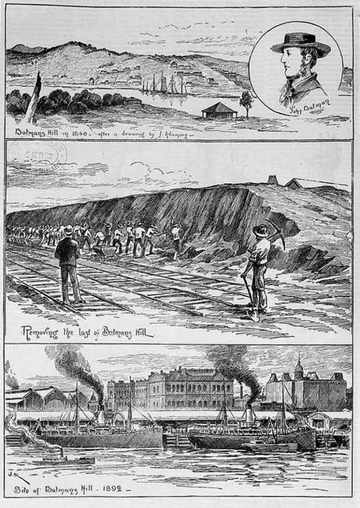
When John Batman first settled the Port Phillip district in 1835, a small hill known as Pleasant Hill was a key feature of the landscape. Elevated land was very desirable in the then swampy river flats along the Yarra River, and John Batman settled on this hill that was to be named after him. However, Batman's Hill also formed a natural confine for the fledgling village, providing a physical boundary between the newly emerging township and salty marshland to the west.
Removing the last of Batman's Hill
In 1836, Sir Richard Bourke, the governor of the Colony of New South Wales, appointed surveyor Robert Russell and two assistants (Frederick D'Arcy and William Darke) to undertake the survey of the Port Phillip district. Along with provisions, Flinders, Grant and Grimes allocated the survey party early coastal maps. However, the poor health of the party's horses, following a protracted journey by sea from Sydney, left the horses weak and unable to travel.
Russell used his time well and undertook a feature survey of the settlement, identifying the natural features such as the course of the Yarra River and existing dwellings that had been built by settlers. These landscape features guided the first settlement in Port Phillip and formed the earliest cornerstones for the ongoing adaptation and development of Melbourne, of which the Docklands development is another exciting component.
In 1837, Governor Bourke appointed surveyor Robert Hoddle to accompany him to the district of Port Phillip to further the progress of survey work commenced by Russell. Hoddle was directed by the governor to carry out the full survey of the settlement.
Robert Hoddle produced the first surveyor's plan in 1837, laying out the streets of Melbourne in their present position. On 7 March of that year, the governor named the settlement Melbourne.
Batman's Hill was the starting point, or datum point, from which Melbourne was mapped. Hoddle's survey equipment comprised a circumferentor and surveyor's chain of prescribed length: 1 chain = 66 feet or 20.12 metres - the length of a standard cricket pitch.
The wider Melbourne grid originated at the datum point at Batman's Hill, from which two primary section lines were mapped. Hoddle set out the two primary section lines from the datum point at Batman's Hill. The lines, one mile north (approximately to the corner of Capel Street and Victoria Street in North Melbourne), and two miles east (creating the corner of Victoria Street and Hoddle Street, Collingwood) formed the basis for all land sales and today's Melbourne metropolitan road network.
Former Victorian Railways Administrative Offices
When it opened in 1893, this substantial Italianate building of five storeys with a basement was the largest office building in Melbourne. The building is now the Grand Hotel and is one of Melbourne's most treasured possessions. Protected by the Heritage Council of Victoria and now fully and beautifully restored to its former grandeur, it is a fine reminder of a bygone era - the Victorian gold rush, where attention to detail and architectural grandeur reigned supreme.
Mission to Seafarers
Located at 717 Flinders Street, the Mission to Seafarers building is definitely worth a visit. Its range of architectural styles includes the Spanish Mission revival style and a more domestic English arts and crafts style in the central section of the building. The domed element of the gymnasium that forms the apex of the triangular site provides an important physical landmark in the area.
Constructed in 1917, the Mission to Seafarers is on the Historic Buildings Register of Victoria. The Mission is an agency of the Anglican Church that offers a range of services for seafarers of all nationalities and creeds.
Queen's Warehouse
The Queen's Warehouse was constructed in 1890 and was first used to administer the colonial customs regulations. Following Australia's federation, the building was used by Federal Customs. Between 1908 and 1924, half the building was taken over by the Department of Treasury.
In 1913, the first Australian commonwealth bank notes and stamps were printed in the building.
Railway No. 2 Goods Shed
The No.2 Goods Shed was built in 1889 to accommodate the increased traffic in the railway yard. Its length - almost two city blocks - and the grandiose architecture of its front offices gives some idea of the scale of operation of the railway yards during the nineteenth century, and the importance of the railway service in the development of this transport complex.
The shed is a heritage-listed building, which ensures the building will be refurbished and integrated into the Village Docklands development. The plan for the shed is to turn it into a marketplace with a large fresh food section and a large, international style food hall.
❊ Web Links ❊
➼ Docklands Precinct Heritage Sites
Disclaimer: Check with the venue (web links) before making plans, travelling or buying tickets.
Accessibility: Contact the venue for accessibility information.
Update Page


