Two Bays Trail - Mornington Peninsula |

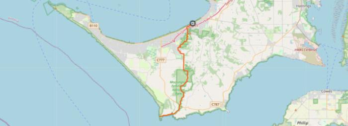
Two Bays Walking Track is a 26.5km, grade 3 hike located in the Mornington Peninsula, Victoria.
Long known as a destination with beautiful beach walks and spectacular clifftop strolls, the Mornington Peninsula boasts one of Victoria's top walks, the Two Bays Walking Track.
The Two Bays Walking Track is the longest continuous walking track on the Mornington Peninsula.
It stretches 26km through a diverse range of Mornington Peninsula landscape. The whole walk can be completed in a day for walking enthusiasts, or split up into multiple smaller walks for those who want to enjoy it in smaller sections. There are also many circuit walks branching off the Two Bays Walking Track through Arthurs Seat and Greens Bush, and occasionally local wildlife such as Eastern Grey Kangaroo, Black Wallaby. Echidna, Koala, Blue Tongue Lizard, Snake species, Eastern and Crimson Rosella, Kookaburra, Grey Fantail and Superb Fairy-Wrens can be spotted.
Start in McCrae on Point Nepean Road and walk up the steep staircase to the top of the cliff and onto Latrobe Parade. Follow the road over the freeway and into Bunurong Track. This is the start of the Arthurs Seat State Park. The winding track climbs the hillside to Seawinds Garden - a popular picnic spot with toilets and electric barbecues. stroll through the magnificent gardens and enjoy scenic view of Port Phillip and Bellarine Peninsula.
The track then continues past the adjoining Kings Falls Track and leaves the State Park at Waterfall Gully Road, before following Goolgowie Street through a Shire reserve to Yambil Avenue along Duels Road and Gardens Road. Follow the symbols on the power poles within this section to navigate between Waterfall Gully Road and Duels Road. Enjoy the views and a rest on the seat provided near Duels Road. This section is particularly steep.
The section between Browns Road and Duells Road follows a narrow road reserve. Crossing Browns Road into Hyslops Road the track joins the Mornington Peninsula National Park section known as Greens Bush.
Crossing small creeks and walking alongside Main Creek the track then crosses Boneo Road and passes Bushrangers Bay on its way to Cape Schanck.
Of course for those still with energy to burn, you could tie this into the Mornington Peninsula 100km Walk that includes walks around Point Nepean, The Coastal Walk and the The Bay Trail
The hike should take around 1-2 days to complete.
Length: 26.5km
Duration: 1-2 days
Grade: 3
Style: One Way
Start: Latrobe Parade at Anthony's Nose
End: Cape Schanck Lighthouse
Location: Mornington Peninsula
Closest town: Dromana
Victoria
From state capital: 87km
Longitude: 144.9563652
Latitude: -38.33691424
❊ Address ❊
⊜ Latrobe Parade Dromana View Map
❊ Web Links ❊
➼ Two Bays Trail - Mornington Peninsula
➼ www.visitmorningtonpeninsula.org
❊ Also See... ❊
➼ Baldry Crossing Circuit Walk - Mornington Peninsula
Disclaimer: Check with the venue (web links) before making plans, travelling or buying tickets.
Accessibility: Contact the venue for accessibility information.
Update Page


